On this page...
The Code of Iowa, CH 418A, as created and signed by Governor Reynolds on June 1, 2023 established the Office of Levee Safety within the Department of Homeland Security and Emergency Management. This office is established as part of a larger levee improvement program designed to reduce and manage risks associated with a hazardous event caused by a levee’s inadequate design, structural performance, or operational control.
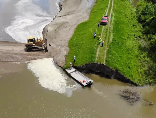
Key tasks for the Office of Levee Safety are to conduct a statewide analysis of the condition of the state’s levees and develop a rating scale to identify the most at-risk levees. The Iowa Geological Survey will survey nearly 900 miles of levees across the state over the next 4-5 years to provide an information baseline regarding the condition of Iowa’s levees. This information as well as inspection reports will be used to develop the rating system. The 2023 fall survey season will conduct geophysical surveys of a carefully selected sample of Iowa’s levees to provide information on a variety of factors such as levee age, levee location, and levee management practices. This initial survey information will be used to develop the initial rating system. Additional survey information gathered in years 2-5 will be used to refine and finalize the rating system.
The Office of Levee Safety will work with levee owners/sponsors to identify potential projects for funding consideration by the Flood Mitigation Board. See the Funding Opportunities section below for more information.
Back to topKey Stakeholders
State
Local
- Levee Owners/Sponsors
- County Auditors
- County Emergency Managers
Federal
Back to topIowa Code
- Primary: Chapter 418A
- Related: Chapter 29C, Chapter 418, Chapter 468
Annual Reports
Back to topSurvey Concept
The geophysical survey of Iowa’s approximately 900 miles of levees is anticipated to take four to five years to complete.
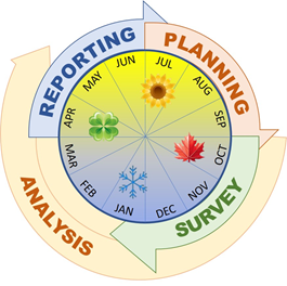
There are four phases in each survey year. They are planning, survey, analysis and reporting.
Electromagnetic (EM) Terrain Survey
EM surveys will be run at the top and base of levees (if conditions allow) identified for this effort. Due to the possibility of multiple passes (top and base), we anticipate up to 200 miles of linear EM data will be gathered along the up to 100 miles identified in the combined levee systems. The EM unit, mounted to a utility-task vehicle for efficient data collection (Figure 2), measures how the subsurface responds to electrical charge. This unit records measurements while in motion and can deliver thousands of data points in a short time. Results from the EM surveys are shown in easy-to-understand color images and are expected to highlight significant changes to levee composition and/or underlying geologic materials such as zones of sand and gravel, unusual groundwater flow paths, or voids that could suggest anomalies.
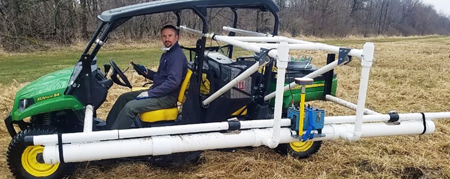
Figure 2. EM geophysical unit on Gator UTV.
Back to topElectrical Resistivity (ER) Survey
The ER method involves physical connection with the ground (via metal stakes) and provides information about the levee and/or underlying materials. Figure 3 shows an example of where the ER will be collected in each of the areas. ER results are shown in cross-section view and provide information about the depth and extent of potential anomalous zones.
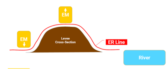
Figure 3. Generalized levee cross-section showing anticipated locations for geophysical data collection.
Back to topGeophysical Limitations
Electrical geophysical methods model how the subsurface responds to electrical charge. These methods provide the best results on undisturbed, natural ground. Data quality can become compromised when run near underground and overhead utilities, drainage structures, surface and subsurface metal, inhomogeneous fill materials, etc. We do expect these features to be present at the sites and will attempt to keep equipment away from these features whenever possible. Electrical geophysical methods are the most beneficial when there is significant electrical contrast between the subsurface target and its surroundings. Geophysical results represent an area generally beneath each transect and may not represent what lies in areas not covered by the geophysical survey.
Back to topFunding Opportunities
A levee improvement fund has been established in the state treasury under the control of the Flood Mitigation Board. For the fiscal year beginning July 1, 2023, and for each fiscal year thereafter through the fiscal year beginning on July 1, 2027, wagering tax receipts of up to $5 million shall be deposited into the levee improvement fund. These funds are appropriated to operate the Office of Levee Safety, conduct a statewide analysis of the condition of the state’s levees, and to award cost-share moneys to levee districts pursuant to the levee improvement program.
Cost-share moneys will be made available to districts whose levee(s) have been surveyed by the Iowa Geological Survey. The levee improvement fund will provide 50% of project costs related to addressing risks associated with inadequate design, structural performance, or operational control.
Back to top